University of Minnesota
http://www.umn.edu/
612-625-5000
http://www.umn.edu/
612-625-5000
Minnesota Biodiversity Atlas
Bell Museum
Dataset: MIN-Plants
Taxa: Abies magnifica
Search Criteria: excluding cultivated/captive occurrences
1
Page 1, records 1-6 of 6
Bell Museum plants | |
 MIN:Plants | 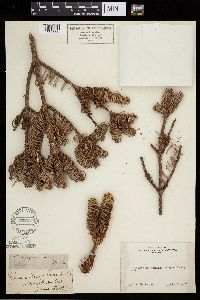 Abies magnifica A. Murray bis 232987[1003066]Congdon, J. s.n.1897-06-05 United States, California, Mariposa, Glacier Point Turnpike;Yosemite National Park;;;, 37.73083 -119.57278 |
MIN:Plants | 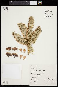 Abies magnifica A. Murray bis 794939[1003065]Schaaf, J. 2141982-10-03 United States, California, Alpine, Toiyabe National Forest. Grover Hot Springs, 2438m |
MIN:Plants | 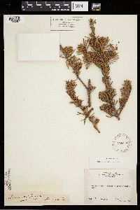 Abies magnifica A. Murray bis 240285[1003067]Congdon, J. s.n.1888-05-26 United States, California, Mariposa, Glacier Point Turnpike;Yosemite National Park;;;, 37.73083 -119.57278 |
MIN:Plants | 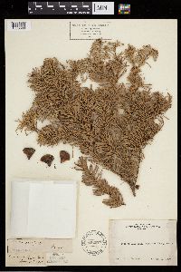 Abies magnifica A. Murray bis 232975[1003063]Congdon, J. s.n.1889-08-22 United States, California, Mariposa, Crescent Lake Trail, Mariposa County;Yosemite National Park |
MIN:Plants |  Abies magnifica A. Murray bis 357722[1003064]Ericson, Mildred s.n.1939-07-30 United States, California, Lower McCabe Lake in the High Sierra Mountains, Yosemite National Park;Yosemite National Park, 152m |
MIN:Plants |  Abies magnifica A. Murray bis 932642[1283465]Ericson, M. J. s.n.1939-07-30 United States, California, Yosemite National Park. Lower McCabe Lake in the High Sierra mountains, 3200m |
1
Page 1, records 1-6 of 6
Google Map
Google Maps is a web mapping service provided by Google that features a map that users can pan (by dragging the mouse) and zoom (by using the mouse wheel). Collection points are displayed as colored markers that when clicked on, displays the full information for that collection. When multiple species are queried (separated by semi-colons), different colored markers denote each individual species.